Well, the first (and maybe last) chase of the year proved to be very enjoyable. In addition to the two brief tornadoes I saw southwest of Chase, KS, I saw some pretty nice storm structure. I also made a lot of great forecasting and nowcasting decisions, making the chase even sweeter.
I set off bound for Russell, KS around 8:30 in the morning. I had figured that I would likely be chasing somewhere around Russell and Great Bend early in the afternoon. Unfortunately, as I was getting onto I-70, I realized that I had forgotten a key tool for the chase, my weather radio. This would be an invaluable tool, especially on the drive home.
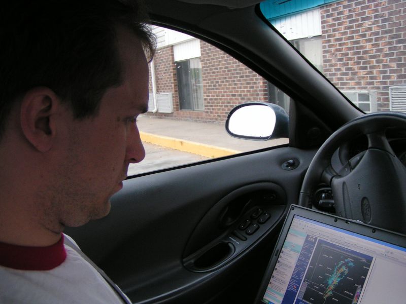 The minor delay helped me out a bit, as I was able to pick up the new convective outlook from the Storm Prediction Center when I stopped at 11:30 in Salina. Open WiFi at the 24/7 gas station in Salina. Excellent! Still a High Risk to my west, and already a PDS Tornado watch just west of Salina. I got a chance to quickly upload a video to the blog from when I was driving before I set out for Russell.
When I rolled into Russell, thunderstorms had already fired ahead of the dry line to the west. After a quick data check, I decided to head to Hays and try to engage some of the storms. I saw some decent storm structure south of town, but nothing terribly exciting. The storm I was following quickly zipped to the northeast and I lost track of it. At the same time, local radio had mentioned that storms were beginning to fire east of the line. Partially out of concern that the leading storms would cut off moisture from the ones I had followed, and concern that the convergence line was shifting east of my location, I decided to punch through the rain on I-70 and head back to Russell to re-evaluate. These storms were multi-cellular and I had concerns that they simply fired up too early.
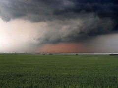 This was one of the best thoughts of the day, as it gave me the ability to stay ahead of the second line of thunderstorms that formed. After another quick data stop, I decided to head south to Great Bend. I hit highway 4, north of Great Bend and decided to head west to get back closer to the line of thunderstorms. One warned thunderstorm would be west of me, and I figured that I would have pretty decent position with them rolling NNE. I had decided that I would probably find a place to sit east of Bison, KS. After starting to get into the rain, I quickly turned around a few miles east of Otis. Another good decision as I started to get hit with hail shortly after I turned around. About 2 miles east of Otis, I decided to pull off on a dirt road and take a look at the storm. I muddied up the car in a hurry, but had a great view of the storm to my west. If something would drop, I would have perfect position to watch it. Although I saw several wall clouds, and a well-defined beaver's tail, nothing ever became of the storm.
At this point, I got my first contact from my friend, Greg Gallina. After following the storm for a half hour or so, I decided to ditch this storm in Galatia, and head back to Russell and to re-evaluate. I probably should have simply gone south to Great Bend, as I would be back tracking that way shortly after I gathered a new set of data. The first wave had sheared out in Colorado, and I would have to wait for the next wave to emerge into the plains.
Back in Russell, the first evidence of the second wave began to fire convection along the dry line to the northwest. I decided that it would still be a good idea to head south to Great Bend. Storms to the south would be a while lot easier to chase, than having to play catch-up with storms moving at 45mph. As I was heading south, the first real tornado warnings of the day began to be issued. While the next line of storms appeared to be forming out toward Dodge City, I felt a lot better chasing a lead storm heading east of Great Bend. It was going to be a long drive back, and I didn't need to add another hour to the trip. Plus, the first storm sounded like it had promise given the warnings that were being issued. I quick call to Greg as I hit Great Bend verified that I would be able to get east of Great Bend fast enough to beat the storm. Greg eventually suggested Chase, KS as a good place to turn south. I had originally thought something further west, but little did I know that the storm motion had changed from NNE to NE. This was a much more favorable storm-relative motion for tornadoes. Good call Greg!
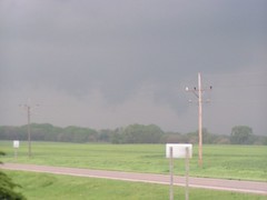 I headed south of Chase after a little bit of rain and set up shop about 2-3 miles south of town. I met up with a few chasers from KC on the road, but didn't want to look like a Yahoo by parking right behind them. I continued up the road to the next hill. To my southwest was a nice rotating wall cloud, and what appeared to be an appendage on the north side of it. I couldn't tell at that point if it was a funnel or simply a part of the wall. After deciding to head back to the other chasers, I found out that indeed, that appendage was a tornado. The three of us reevaluated our position, which included looking for a cyclic mesocyclone to form. As the storm grew closer, we decided to head out. Unfortunately, I had no idea how far the dirt road I was on went. I didn't want to be caught too close to the storm. After a minute to reevaluate, I decided to head north to Chase. On the way, I heard a radio storm chaser declare a tornado touchdown. I looked in my rear-view mirror and out the back window to find that at tornado was indeed on the ground, likely very close to where I had just left. I quickly pulled over to at least get a picture, but by the time I jumped out of the car, the tornado was lifting. I didn't realize I had the camera on video mode at the time, but before I zipped away from the storm, I got a quick snapshot of the dissipated tornado.
With very little good north-south options, I ended up heading further east than I wanted and decided to re-intercept the storm north of Lyons. Unfortunately, by the time I got there, not only had the mesocyclone become rain wrapped, I was a little too far east to see much. After chatting with another chaser for a while who had outdated radar information, and consults with Greg, I eventually decided that I'd wait for the storm to pass to my north, and then head west to catch a thunderstorm that had dropped a tornado just southwest of Great Bend. I headed east of highway 4 to Bushton. After pulling off the road, I quickly realized that the storm was considerably further west, and I hopped onto highway 156 to parallel the storm. Even this seemed to be too far east, so I followed what appeared to be a line of chasers up Barton County road about 15 miles south of Wilson.
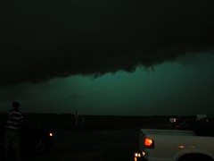 This was pretty much open country and I had little around me to estimate how far north I was as I proceeded. This proved to be rather nerve racking, as rain-wrapped tornadoes continued to be reported out of this storm. In addition, I'd periodically look up after pulling over to find an eerie green glow to the clouds above me. Not in the mood to get pelted by hail, I'd reposition. I caught some nice shots of the green thunderstorm as it went west of us just before sunset.
Eventually, I knew that I needed to get to Wilson and head home. Unfortunately, I kept hearing reports of a rain-wrapped tornado near Wilson. I proceeded with caution for much longer that I would have liked. After some time, a report came in that the tornado was about to cross I-70. Still not knowing how close I was to Wilson, I waited for verification that the storm was on the other side of the interstate before I headed the extra few miles north to Wilson. Despite the poorly marked roads and partially flooded streets in Wilson, I found my way to I-70. Just before hitting the interstate, I ran into some shredded wood planks on the road. It appeared to be some sort of tornado damage, but it was dark, and I couldn't see much. I was just glad I hadn't punched north sooner; otherwise I could have been one of those planks.
I mentioned that the weather radio would be invaluable on the ride home earlier. Well, as I headed east of Salina,  I heard a tornado warning come across the radio declaring there was a storm ahead of me with the possibility of a tornado. Kudos to the folks at the NWS Forecast Center in Topeka, as they made sure to include mile markers along I-70 to avoid. As this was 10 miles ahead of me, I was able to pull over at a rest area and let the storm pass. This only further delayed my arrival home as I finally rolled in around 1am after putting 750 miles on the car, and knocking a plug out of the transmission.
All in all, it was a very successful chase. Despite the limited weather information I had, I made some great decisions. Greg was a big help, especially in diagnosing the first wave shearing out, and the call on Chase, KS. I was able to find a few places with open WiFi, which helped as well. As much as I love to see Mother Nature’s beauty and power, it was very fulfilling to make some good meteorological decisions that put me in place to see it all unfold.
If you want to see a full set of the pictures I took on the chase, check out my
Flickr page. I still want to play with the image of the dissipating tornado above and see if I can correct some of the lighting.
Labels: storm chase, thunderstorm, tornado


0 Comments:
Post a Comment
<< Home