
Forecast verification and winter storm graphics #2
The National Weather Service had a nice write-up on the storm from Wednesday and Thursday. They've posted a few more graphics over at their website at http://www.crh.noaa.gov/eax


Click on the images to enlarge
Compare that graphic with my snow forecast, and you'll see that I was a bit too far northwest with the forecasted snowfall on the whole (by about 25 miles), and I didn't anticipate the marked cutoff in snow totals as noted in northern Missouri, down the I-29 corridor. I also over estimated snow totals in the heaviest band by 2-3 inches.
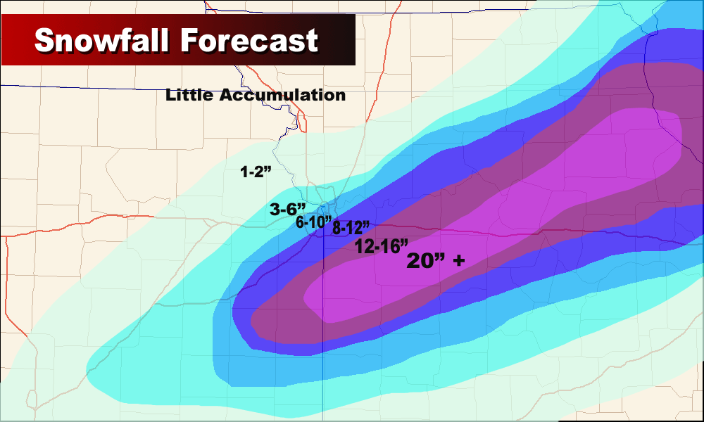
Forecasted snow on Wednesday night
Click to enlarge
All in all... given the chaos that was the computer models on this storm, I did pretty well. Plus, I stuck to my guns through Thursday morning, unlike many meteorologists in town who went back and forth on their forecasts. I would have liked to have done better several days out when I mentioned that the trend would take the storm further south so that we wouldn't see much, if any snow. I also underestimated the push of the cold air at the surface on Wednesday that ended up producing the ice (however, I did nail the sleet).
Thank you to all of you that checked out the web site during the storm. The site received a record number of hits Wednesday and Thursday. I encourage you to check in every day for the forecast, and to subscribe to the podcast in iTunes at http://feeds.feedburner.com/kcweatherpodcast
Labels: map, snowfall, verification


0 Comments:
Post a Comment
<< Home