
Google Maps - Atlantic Hurricane Path Tracking
I came upon this link through Digg.com earlier today and thought I'd share it with you...
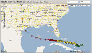
Thanks to the Google maps interface, this site allows you to track hurricanes past and present. Present data uses the hurricane track from the National Hurricane Center / Tropical Prediction Center. Do you want a cool way to see exactly where the NHC is predicting where Rita will make landfall? Check this out!


2 Comments:
Was hoping to give you credit for being current and have actual live satellite images with limited mouse clicking into sites but since your down there doesn't seem to be any difference in all weather sites like yahoo and msnbc and khou and others.
I'm not really the source for up-to-date information on the hurricane. If you would like this kind of information, visit the National Hurricane Center/Tropical Prediction Center website. There are links to storm-centered satellite images. They are much better than Yahoo and MSNBC.
Post a Comment
<< Home